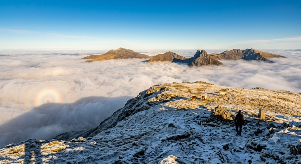
There is a particular kind of morning that makes you feel like you have broken some rule of physics. You park in a cold, grey layby and pull on a hat. You walk uphill through damp bracken and low cloud, unable to see much beyond a radius of about fifteen metres, wondering whether you have, once again, misjudged conditions badly enough to make a reasonable case for turning around. And then, at some unmarked line somewhere around seven or eight hundred feet, you step out of the cloud altogether. The valley below disappears. The sky above is a hard, cloudless blue. You are standing in sunlight on a hill that, thirty minutes ago, appeared to be buried under the most thorough greyness the British climate could produce.
This is a cloud inversion. It photographs spectacularly. It looks even better in person.
What Is Actually Happening
The science is not especially complicated.
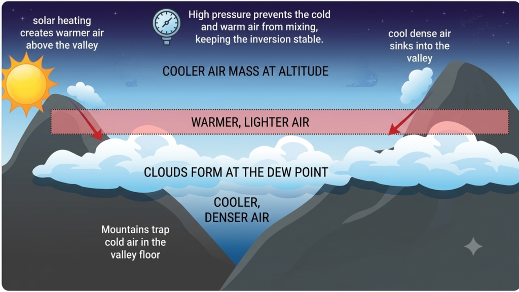
Normally, air cools as it rises. This keeps weather broadly organised: warm, turbulent air rises, cold air sinks, clouds form at altitude, and the general principle holds that things get worse the higher you go. A temperature inversion reverses this arrangement. A layer of warmer air sits above a layer of cold air, like a lid on a pot, trapping everything beneath it. Cold air near the ground, unable to rise through the warm layer above, pools in valleys and hollows. Moisture condenses into fog or low cloud, filling the landscape from the bottom up.
The hilltops, sitting above the inversion layer, are in a completely different atmosphere: calm, dry, and often unexpectedly warm for the time of day. The temperature at the summit can be noticeably higher than the temperature at the car park. If you have ever walked into a field of golden light while the village below you remains visibly grey and wet, you were experiencing an inversion and, possibly, feeling quietly smug about it. Both responses are appropriate.
How the Inversion Forms
There are two main ways this inversion layer forms. The first is overnight radiative cooling: on a clear, calm night the earth loses heat rapidly, cold air drains downhill, and valley moisture condenses into fog that may persist until mid-morning. This is the classic autumn and winter mechanism. The second is high pressure subsidence: when a high pressure system sits overhead for several days, air descends slowly through the atmosphere, warming as it compresses. This creates a warm lid at altitude while moisture remains trapped in the cooler air below. Both produce the same result from a hilltop. The high pressure version can arrive at any time of year, including midsummer, when a slow-moving anticyclone draws humid air up from the south and locks it beneath a descending warm layer.
One detail worth knowing: an inversion cloud layer sits differently from ordinary cloud. The top is flat and smooth, almost lacquered-looking, because the stable air suppresses any vertical mixing. Ordinary convective cloud, the kind that builds into showers or thunderstorms, looks clumpy and turbulent by comparison. When you look out at a flat white sea below a summit, that laminar surface is the physical signature of atmospheric stability: nothing is moving upward through it.
Where to See Them in the UK
The British uplands are, structurally, ideal inversion terrain: narrow valleys flanked by ridges of five hundred to four thousand feet, with enough maritime moisture from the Atlantic, the Irish Sea, and the Severn Estuary to ensure there is usually something to invert. Almost any area with meaningful elevation change and a proper valley floor will produce them. These are the locations worth prioritising.
Wales and the Borders
The Brecon Beacons / Bannau Brycheiniog are among the most reliable destinations in Wales. The main ridge, from Pen y Fan west to Fan Brycheiniog, sits well above the Usk and Taff valleys, both of which fill beautifully with cloud on the right morning. The views west from Corn Du can, on a good inversion day, look roughly like a satellite image of a cloud system taken from inside.
The Black Mountains, and particularly the ridge between Hay Bluff and Lord Hereford’s Knob, offer a slightly quieter version of the same experience. The Vale of Ewyas fills with cloud in a way that makes Gospel Pass feel like the edge of a different world. It is not especially dramatic to drive over in summer. In October at eight in the morning, it is a different matter.
Snowdonia / Eryri produces some of the most dramatic inversions in the country, largely because the valleys are deep and the ridges are high enough to guarantee clear separation between cloud and summit. The Ogwen Valley fills particularly well. From Y Garn or Tryfan’s north ridge in the right conditions, the Llanberis Pass disappears entirely beneath a flat white ceiling.
England
The Lake District offers inversions on a different scale: the major lakes, Windermere, Ullswater, Coniston, sit in glacial valleys that trap cold air with unusual efficiency. The view from Helvellyn looking west over a cloud-filled Thirlmere, with the Coniston fells visible above the far edge, is as good as British landscape gets.
The Yorkshire Dales, particularly Wharfedale and Swaledale, fill with a low, rolling mist on autumn mornings that gives the stone walls and village rooftops exactly the appearance they deserve. Great Whernside and the Buckden Pike ridge both give enough height to break clear. The distances involved are smaller than the Lakes but the results are comparable.
The Peak District is underrated for inversions, partly because the plateau character of Kinder Scout and Bleaklow does not immediately suggest valley views. But the Hope Valley and Edale fill reliably in settled conditions, and the view from Mam Tor across a cloud-buried Vale of Hope is one of the Peak’s better-kept secrets.
Dartmoor works differently from valley terrain: here the moor itself can be above the cloud, with the whole tor-scattered plateau rising from a grey sea that covers the lower farmland. High Willhays and Yes Tor, modest in height but high relative to the surrounding lowlands, are occasionally the only visible ground for miles.
Scotland
The Scottish Highlands are in a category of their own. Glen Coe, framed by the Aonach Eagach ridge and the Buachaille, fills with cloud that photographs like a film set. The Cairngorm plateau, when the glen below is socked in, sits above it in the kind of Arctic clarity that has no equivalent further south. These are not mornings to miss, and they are not mornings that are easy to predict. The conditions come together less reliably than further south, and the window at the top before cloud reforms can be short. But when they work, they work completely.
The Conditions to Look For
Knowing that inversions exist is only modestly useful. Knowing when to go is the actual skill.
The checklist is, more or less, this: high pressure nearby and slow to move, little or no wind, and plenty of low-level moisture. That moisture can come from recent rain or from air that has tracked up from the south over the sea. A landscape with meaningful elevation change between valley floor and ridgeline completes the picture. An absence of frontal systems is essential: a front coming through resets the air mass entirely, and the delicate balance of temperature and moisture does not survive it. Autumn and early winter are the prime season — longer nights cool the ground more thoroughly, and the lower sun struggles to burn off cloud once it has formed — but a slow-moving summer anticyclone with humid southerly air beneath it can produce inversions that are, if anything, more extensive.
The frustrating thing about inversions is that the conditions that produce them are also the conditions that look, from the valley, exactly like the conditions that will produce a deeply grey, cold, unrewarding morning. Standing in your kitchen at seven-thirty, looking at fog, requires a certain faith in the instrument readings rather than the view through the window.
Which is, not coincidentally, why I built a tool for it.
The Cloud Inversion Predictor
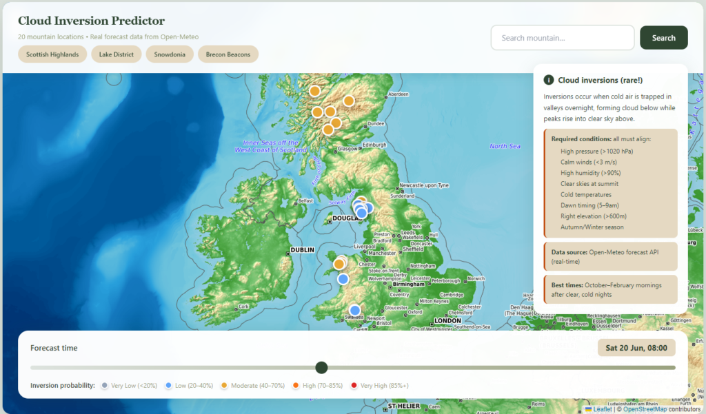
Rather than squinting at the Met Office synoptic charts and trying to hold dew point spread and wind shear at two thousand feet in your head simultaneously, I put together a cloud inversion predictor.
It pulls together the relevant conditions (overnight temperatures, dew points, wind speeds, forecast cloud base heights) and gives you a read on whether a given morning is worth the alarm. Weather forecasting at the resolution required to say “the cloud will be at precisely nine hundred feet on the Skirrid Fawr by eight-fifteen” is beyond any tool built or encountered. What it does is narrow the field considerably.
If the predictor says the conditions look promising, it means the overnight readings are trending in the right direction: cold, calm, and moist enough at valley level, clear above. If it is sceptical, one or more of the key conditions is missing.
The sweet spot, from experience, is a good forecast combined with a clear night the evening before, no wind to speak of, and the willingness to arrive at the trailhead before nine. The cloud often burns off by mid-morning once the sun gets to work. Arriving at seven-thirty rather than ten can be the difference between a photograph that stops people mid-scroll and a pleasant walk in slightly unusual cloud.
Check today’s cloud inversion forecast here.
Not Every Inversion Is Equal
Some mornings the cloud is too thin to produce a convincing sea effect, and what you get is a slight blurring at valley level and an otherwise ordinary hilltop view. On other mornings the inversion layer sits too low to clear from the nearest accessible summit, and the only people getting the full benefit are the occupants of a five-storey building somewhere in Abergavenny. Some mornings you drive two hours, hike eight hundred feet, and step out of the cloud into a thin, pale layer of sky that is technically above the inversion but does not feel especially triumphant.
These mornings still count. The walk is still good. But the predictor helps filter for the mornings when conditions align in your favour.
When it works, it is genuinely one of the better things British walking has to offer: a landscape that most people will never see, a view that does not appear on any summer weekend. The particular satisfaction of having read the weather correctly and acted on it while most people were still asleep. The alarm goes off at five-thirty. Outside, it is grey and damp and entirely unpromising.
You get up anyway.
Leave a Reply