A Wainwright walk. Lake District. This one earns the exception.
At a Glance
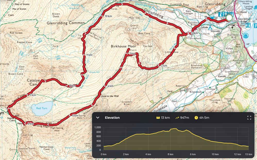
| Distance | 8 miles / 13km |
| Elevation gain | 820m |
| Summit | Helvellyn, 950m |
| Time | 5–7 hours |
| Difficulty | Strenuous (Grade 1 scramble) |
| Start/Finish | Glenridding car park, CA11 0PD |
| OS Map | OL5: The English Lakes, North-Eastern area |
Watch the Full Route
Striding Edge gets talked about in a particular way. People describe it, usually to people who have not done it, with a facial expression that suggests mild trauma and quiet pride in roughly equal measure. “Oh, you’re doing Striding Edge,” they say, and the “oh” does a lot of work. It implies vertical drops, exposure, hands-on-rock, and at least one moment of wondering whether the Lake District was really worth the drive up.
While it is a walk that should be treated with respect, it is achievable by most people of reasonable fitness with sensible gear and preparation. If you are less experienced mountain walker, make sure you look at the forecast and attempt it only in good weather.
But it is, at its core, a very good ridge walk with one genuinely committing section, and the walk around it, including the summit of Helvellyn and the bonus peak of Catstye Cam on the way back, is one of the finest mountain days available on foot in England. Not one of the finest in Cumbria. In England.
Getting There and Parking
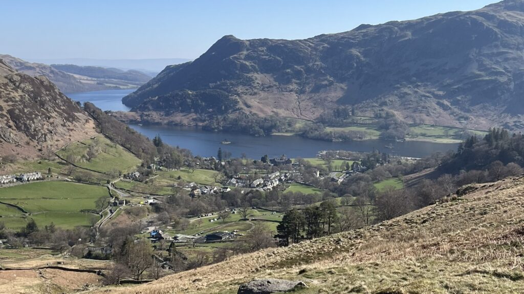
Glenridding sits at the southern end of Ullswater and has a large pay and display car park right in the village (CA11 0PD, grid reference NY385169). Arrive early at weekends: this is one of the most popular walks in the Lake District, and the car park fills in a way that suggests everyone in the Midlands had the same idea at the same moment. Weekday mornings are considerably quieter, which I mention because I did this walk on a weekday morning in April and the ridge was still reasonably busy and the light was unreasonably good.
There is a bus service (the 508 from Penrith), which solves the parking problem entirely if you are not driving.
The Route
Glenridding → Birkhouse Moor → Striding Edge → Helvellyn → Swirral Edge → Catstye Cam → Glenridding
Glenridding to Birkhouse Moor
From the car park, cross the beck and follow the path south through the village, then east, rising steadily up the flank of Birkhouse Moor. This first section is the walk’s longest continuous climb: around 400 metres of ascent on a good, clear path that allows you to settle into the effort and make the first of several decisions about layering. The views back down to Ullswater open up quickly and provide the first of many reasons to stop and look behind you.
Birkhouse Moor (a Wainwright summit) is a broad, open fell with little drama. It is also where you look ahead for the first time and see the full extent of what is coming.
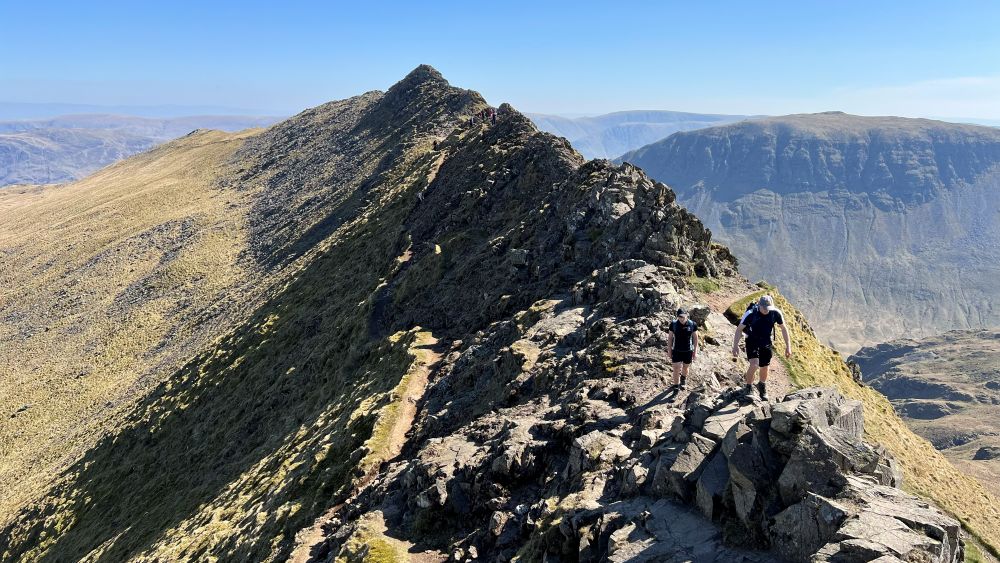
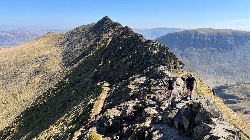
Striding Edge
Striding Edge is approximately 800 metres of rocky ridge connecting Birkhouse Moor to the Helvellyn summit plateau. It runs east to west, which means you walk it into the light on a morning ascent, which is either a problem or not a problem depending entirely on your sunglasses situation. On either side: steep drops onto scree below, both of which become theoretical rather than concerning once you are actually on the ridge and too busy watching your feet to think about anything else.
The path along the crest is not hidden. You follow it. There is one section near the far end, where the edge meets the summit crags, that requires a genuine descent on hands and feet: a short, chimney-like step that sends roughly a third of walkers briefly into their own heads. It is over in about twenty seconds. The remaining two-thirds are already on the other side, looking back with the expression I mentioned in the first paragraph.
What you are on is a Grade 1 scramble. Confident walkers with a head for heights will be completely fine. If steep, exposed terrain makes you freeze, that is worth knowing about before you are on the ridge, not after. The ridge is also entirely avoidable by taking a small path that runs parallel to it on the right hand side.
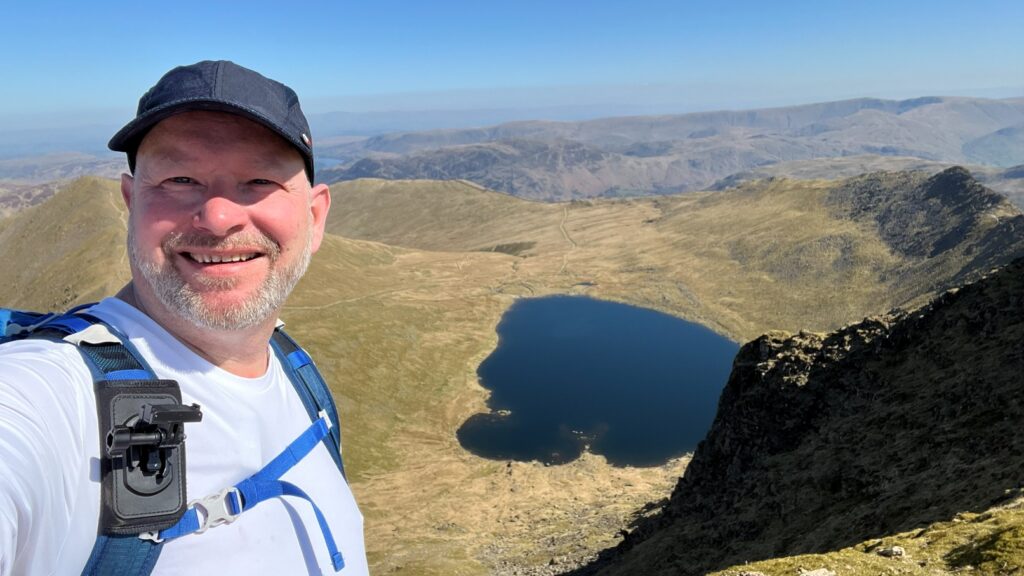
Helvellyn Summit
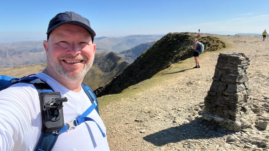
At 950 metres, Helvellyn is the third highest peak in England and one of the more sociable ones: on a clear weekend, the summit feels less like a mountain top and more like a particularly exposed village fete. There is a cross-wall shelter, a trig point, and on the day I visited, a man eating a sandwich with the unhurried composure of someone sitting in his own kitchen.
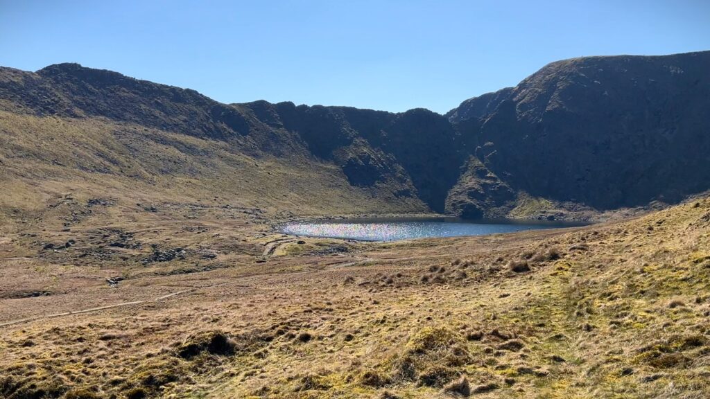
The views are, on any reasonable day, enormous. Striding Edge unfurls below you to the east. Swirral Edge drops away to the north. Red Tarn sits in the bowl between them, a cold grey-blue even in April sun. Ullswater is visible behind you. Ahead, on a clear day, you can see into Scotland.
Give the summit the time it deserves. You have earned it.
Swirral Edge
The descent from Helvellyn onto Swirral Edge is shorter and steeper than the Striding Edge ascent but less technically demanding. It drops quickly to the col between Helvellyn and Catstye Cam, where you face a choice: return directly to Glenridding via the path above Red Tarn, or add Catstye Cam.
If you are bagging Wainwrights or have the time and are feeling fresh, add Catstye Cam.
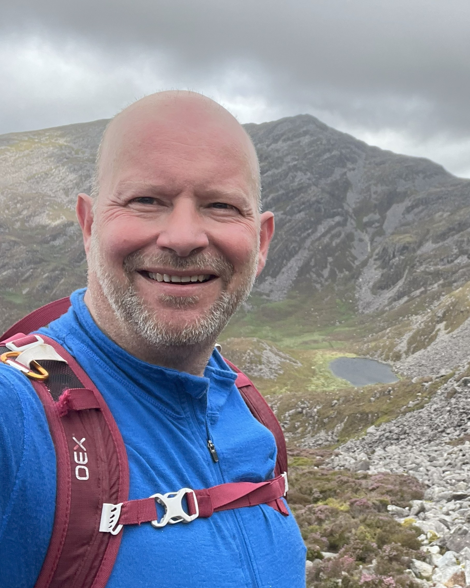
Catstye Cam
It is thirty to forty minutes of extra walking for a summit that most people skip, and which, partly as a result of this, has an atmosphere of its own: quieter than Helvellyn, slightly more pointed in its shape, with a view back along the ridge you have just walked that is worth every minute of the detour. From up here, Striding Edge looks exactly as serious as people say it is, which is satisfying in the way that most things are more satisfying once you have already done them.
The Descent
From Catstye Cam, the path drops clearly from the summit and follows Red Tarn Beck back down into the valley, returning you to Glenridding with tired legs, and, if the day has gone well, a fairly complete sense of having used the time correctly.
To view the full route in detail see my route map where you can get links to download the GPX files and view the route on Hiiker
What to Bring
A mountain walk at nearly a thousand metres, with an exposed ridge running through the middle of it, deserves to be treated like one. Full waterproofs. A base layer and an insulating mid-layer. Walking boots with ankle support and a sole that grips on wet rock. Trekking poles take the edge off both the Birkhouse Moor ascent and the long descent at the end. An OS map and compass: the summit plateau can disorient in cloud, and the ridge will be far less enjoyable if the weather closes in and you cannot read a map.
For a full list of the kit I use on walks like this, including the exact gear I carried on this route, head to the gear page.
A Few Things Worth Knowing
Helvellyn via Striding Edge is not a walk for beginners, and this is not a caveat: it is useful information. It is an excellent walk for people who are comfortable on mountains, have done some ridge walking before, and own kit that matches the terrain. The technical section is short, but the exposure is real, the ground is unforgiving, and the mountain rescue teams are called out on this route regularly, mostly by people who underestimated either the terrain or the weather.
Check the forecast before you go. Bring a map. Tell someone where you are. Wear boots, not trainers.
That said: go. It is, by a wide margin, one of the finest days you can spend on foot in England, and the view from Catstye Cam looking back at the ridge you have just walked is the kind of thing you think about on the drive home.
This walk is part of my Wainwrights series. More Lake District routes coming.
Leave a Reply